Consider for a moment that electronic commerce make up only a tiny portion of all retail sales anywhere in the world. Bearing this fact in mind, it is critical, therefore, for businesses in almost any industry to get customers to the nearest location where their products or services are being sold. Providing an address and a phone number is not enough to ensure that a customer will arrive at a particular location. Today's consumers increasingly demand constant access to detailed and accurate information about products and services and their most convenient locations. A product or service without a clear, corresponding location results in a lost opportunity for the business and an inconvenience for the customer.
GIStance, consequently, has developed a cost effective and customer focused package that allows those with even the most basic computer skills to take advantage of location based services. Attaching a GIStance Navigator to your web-site can add a new dimension to how customers or prospective customers view your business. Our locator can help remove any uncertainties surrounding store locations, available products and services, business hours, contact names, and a whole lot more. Uncertainties and inconveniences can cost your business a lot of money. The world needs to know your place.
Constructing The Navigator
When constructing the Navigator, GIStance went through the following three major steps:
- Building the map.
- Displaying the map.
- Customizing the map.

Step 1: Building the Map
GIStance has extensive experience in providing GIS services to the European Union Satellite Center and to the E.U. Commission. This knowledge has now been used to create the GIStance Navigator package, which can help your business to maximize the value of its web presence.
|
When creating the Navigator, GIStance first acquired a satellite image of Budapest. Using a GIS software package from ESRI and this satellite image, we created a vectorized database by drawing lines over all of the streets and public transportation routes at high resolution. Similarly, colored polygons were drawn over parks and water areas. Point layers may be used to mark specific areas of interest such as banks, gas stations, real estate, or store locations. Figure 1 shown to the right provides an example of how we used a satellite image to build our digital map of Budapest.
|
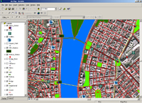 Figure 1
|
Step 2: Displaying the Map
A vectorized database by itself is of no real use. The data needs to be transformed into usable information and then integrated into a software application that can meet the needs of the user and the client. Important elements of a successful, on-line map for the users and clients are as follows:
For the user:
- Simultaneously informative and innovative.
- “A picture is worth a million words”.
- The application loads fast and operates without delays.
- The high quality imagery makes finding a location very easy.
- Simple to use for those with basic computer skills.
- Appealing graphics and design.
For the client :
- Adds value to store locations by removing location uncertainties.
- Allows customers to easily find their most convenient location.
- Highly cost effective.
- Highly flexible.
- Memorable for the user.
- Attracts more traffic to web-site.
Partnering with TimeMap
Mapping has become an important part of communication for companies who seek to realize the true potential of the Internet. Before GIStance could satisfy the needs of both the users and the clients, we had to consider many different factors before designing our Navigator package.
Our search led us to create a partnership with TimeMap , a development group supported by the University of Sydney and top industry players. The TimeMap technology, called TMJava, has provided us with a unique way to publish interactive maps on the Internet while using only a few simple lines of html. The TMJava can easily be embedded in any web page and act as an interface to map data located on the web-site or to internet accessible datasets.
The TimeMap technology has allowed us to transform our vectorized database into a
living, breathing, interactive map. This technology enables the user to move way beyond the limitations of static jpg map images that are commonly used. The effectiveness of the technology is directly related to the interaction between it and the user. Our Navigator package delivers exactly this.
Constant Technical Support
A major advantage of partnership with TimeMap is that fact that they provide constant technical support for all of its licensed technologies. The Sydney-based team of software and application developers can provide rapid response technical support to members of the TimeMap Open Source Consortium, including the development of new functions as part of the core software and custom development of specialized functions where necessary.
The GIStance Navigator package is one that is constantly evolving through our own efforts and through the emerging technologies of TMJava.
Step 3: Navigator Customization
It is typically the case where a company has a web-site, but that it offers nothing in way of location based information. This situation can be changed quickly with the addition of the GIStance Navigator. To view some Navigator customization examples, please check out our Regal Real Estate demo.
When customizing the Navigator package, we offer two main options for options for our customers: full service and stand alone.
Service Option
This option is reserved for those businesses that do not wish to manage the Navigator in-house. Adding a Navigator involves the following steps:
- Provide us with all of your location addresses and all of the specific information related to this location. This information may include store hours, prices, promotions, addresses, web-site addresses, e-mail addresses, phone numbers, etc. The more information that is provided, the more useful of a tool the map will be for your customers.
- GIStance will create a separate web page hosted on our map server . This customized page will display a highly detailed map with your location specific information on it.
- Place a link on your web-site for the GIStance web page displaying your new company navigator.
- Send e-mails or phone GIStance to have the map content updated at your convenience.
- GIStance will periodically update the Budapest map to eliminate any outdated information.
Stand Alone Option
This option is reserved for companies that would like to purchase the Navigator package and maintain the map in-house.
Points of interests of the following:
- GIStance will create a basic map based on the specifications of the client before the final product is delivered.
- We will provide a day of consulting to make sure the package is received, installed, and functions properly.
- The stand alone Navigator package includes full support from TimeMap, as well as ongoing GIStance support.
- GIStance will periodically update the Budapest map and provide a new database as a part of our ongoing support.
Navigator Mobile
One of the existing developments in progress is the Navigator Mobile package. The Navigator Mobile package will allow customers to access map information over their mobile phones.
The Navigator Mobile test version is scheduled for the second half of 2005.
What is the Value of a Locator?
As it was mentioned in the very beginning of our materials, electronic commerce may be growing significantly year over year, but it is still a tiny slice of the whole, world commerce pie. This fact will remain for decades to come. It is, therefore, still incredibly important for companies to attract existing customers and prospective customers to their places of business. If the customers do not come to the stores, then how can business exist if electronic commerce is still nothing but an infant?
While the Internet is still not commonplace for on-line shopping, it is now widely used for information searches. Internet connections are growing at a rapid rate and consumers are learning to use the Internet to gather useful information pertaining to almost anything. One thing they are searching for is more information about your products and services and where they can purchase them. Company web-sites are very useful tools to help inform consumers and attract them to your stores. There is just one thing missing….
Customers need to know the precise locations of businesses and do not want to spend their days searching around for a particular place. It is the job of the web-site to help consumers to easily find company locations and to provide them with useful information at the same time. The results are powerful and remarkably clear: convenience for your customers means money in your bank.
The world is becoming more and more location specific and getting lost is just too expensive. Does the world know your place?
|